ONOVA GIS HUB
Founders of the project:
Public union "Ukrainian Fund for Energy Efficiency and Energy Saving",
The Esri company (USA) is a world leader in the software market of geographic information systems (GIS), location analysis and mapping,
Public organization "Elektronna Ukraine"— a portal of digital transformation of Ukraine.
Presentation of ONOVA GIS HUB
The organizational structure:
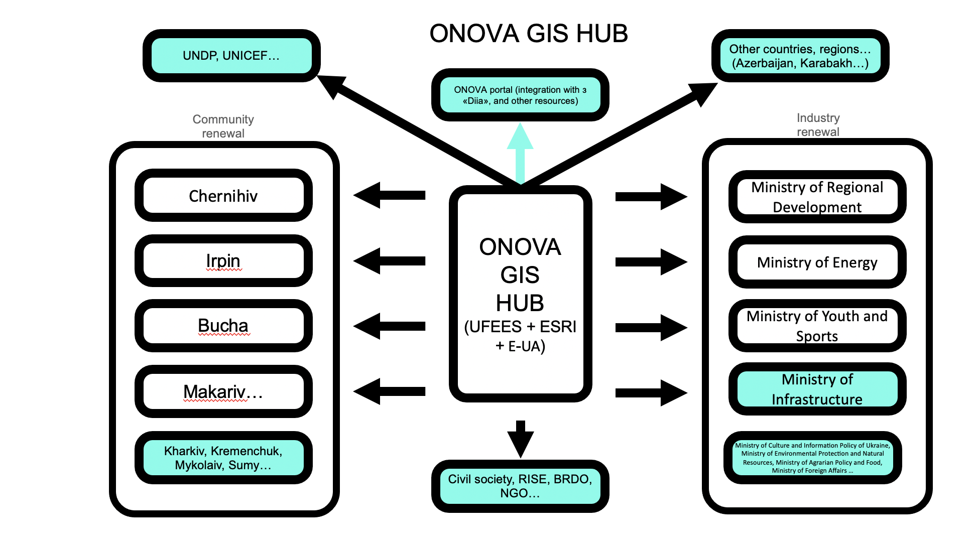
Main functions of GIS HUB:
Fixation of destruction.
Restoration and development of regions and industries in accordance with updated plans.
Transparent attraction of investments for damaged objects
Management decision support system
Control of the process of updating objects, communities, industries, and the country
The possibility of interaction with the owners of destroyed objects
Data protection
An analytical opinion was obtained from the relevant specialized organization regarding the level of information security in the web service and the protection system, therefore its use is safe.
Each user of the web service is given an appropriate role for data management, observing the mechanism for ensuring confidentiality in the mode of public and special access to this data.
Preliminary assessment conclusion_ArcGIS
Access and authorization
Access to the web service (personal login, password) is provided to users to maintain the database in accordance with the transfer acceptance act.
The web service has a closed and a public part.
Closed part. Access is provided only by the administrator of the web service and an authorized person through the electronic cabinet
The public part will be freely accessible to users of the web service and other persons in accordance with the accepted norms during martial law. Consists of integrated resources, including geospatial information.

The portal for recording the destruction, reconstruction and renewal of the infrastructure of Ukraine
More than 12,000 objects of various infrastructures of Ukraine have been mapped
Map of humanitarian aid points location
Map of temporarily displaced persons
The project has already been reached
Ministries — Ministry of Regions, Ministry of Energy, Ministry of Youth and Sports (negotiations are underway with others), communities — 20 communities, including the hero cities of Irpin, Bucha, Makariv, Chernihiv, Mykolaiv.
Esri, a recognized global leader in the GIS software, geoanalytics, and mapping market, has published a case study on the implementation of geoinformation technologies in Ukraine on its official website.
Case study on the Esri website ONOVA GIS HUB
Renovation projects:
Reconstruction of Lyceum № 3 in Irpin, Kyiv region
Chernihiv regional youth center
State Enterprise "Olympic Training and Sports Center "Chernihiv"
Renovated facilities:
Reconstruction of the school named after Zarifa Aliyeva in the city of Irpin, Kyiv region


